Technology Integration
Drone Integration: Aerial Eye Connected to Command Center
A drone without connection to the command center is just a flying camera. Integrated with KabatOne, it is an operational unit: the dispatcher sees the aerial feed, GIS shows its real-time position, and the system can automatically dispatch the drone to the next incident from its dock.
Drone Integration Capabilities
KabatOne transforms the drone from an isolated tactical tool into an integrated unit of the public safety platform:
Real-Time Telemetry
GPS position, altitude, speed, battery, and drone status transmitted in real time to the K-Safety GIS map. The drone appears as another operational unit alongside field vehicles and personnel.
Live Aerial Video
Drone camera feed ingested into K-Video with under 1-second latency. Operators and dispatchers access the video from the same interface used for fixed cameras — no separate applications.
Automatic Dispatch from Dock
With drones in dock stations, K-Dispatch can automatically send the drone to an incident location. The drone takes off, navigates, and transmits video before ground units arrive.
AI Analytics on Aerial Video
K-Video algorithms run on the drone feed: person detection, plate reading at low altitude, crowd counting, and real-time abnormal behavior detection from the air.
Multi-Drone Fleet Management
KabatOne manages multi-drone fleets from a single interface: patrol zone assignment, mission scheduling, battery and dock status monitoring, and complete flight logging.
Documented Digital Evidence
Every flight generates an immutable record: GPS route, full video, operator, timestamps. Material is admissible as evidence with documented chain of custody — from dispatch to landing.
Operations Where Drones Make the Difference
Scenarios where integrated aerial capability changes the operational outcome:
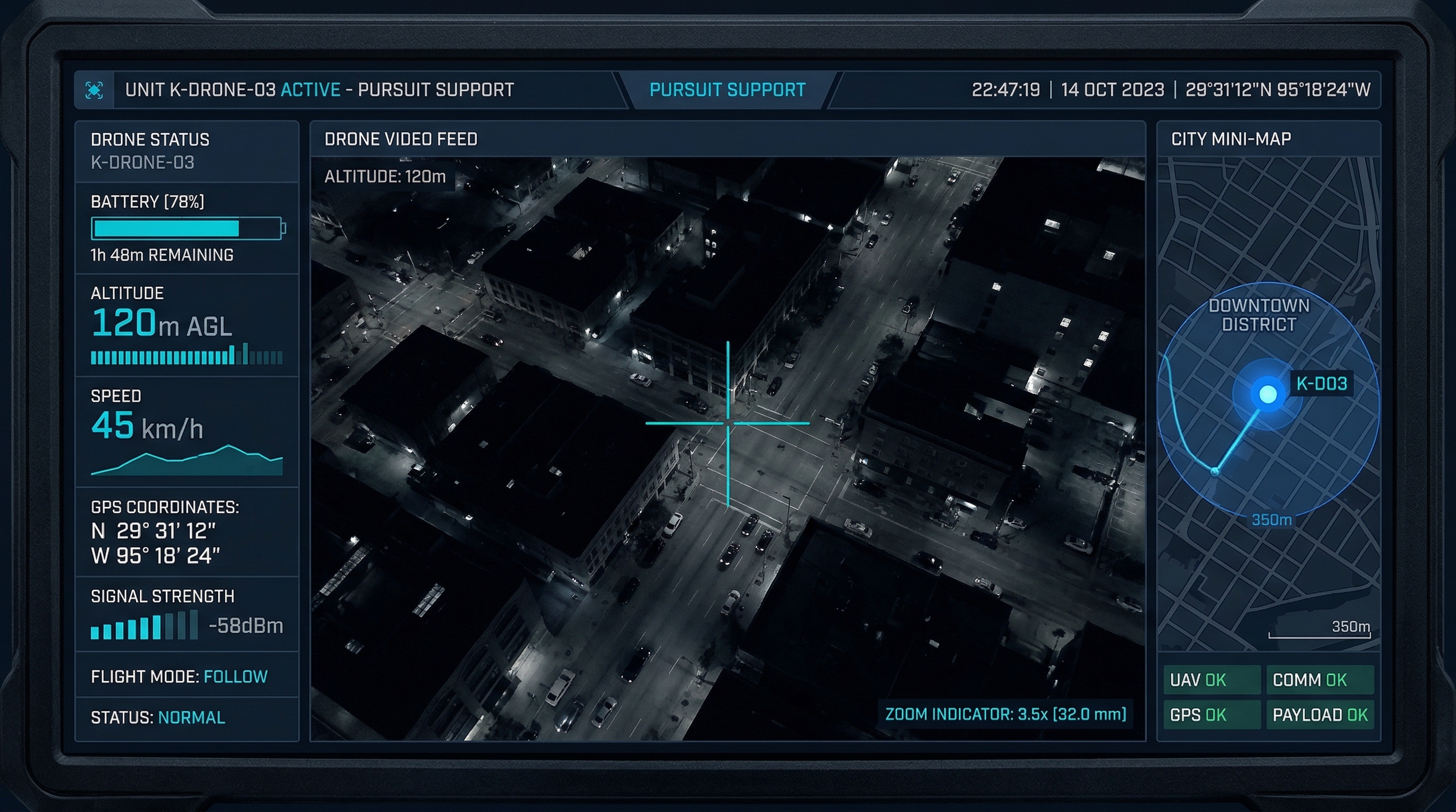
Pursuit Support
When a unit initiates a vehicle pursuit, the nearest available drone automatically launches and maintains the vehicle in aerial tracking. The dispatcher has continuous aerial vision — even when the vehicle is out of sight of fixed cameras or when ground units fall behind.
Search and Rescue
In search and rescue operations across large areas (forested zones, urban peripheries, natural disasters), a drone with thermal camera can cover in minutes what would take hours on foot. KabatOne integrates the drone's thermal feed into the operations map with ground rescue teams.
Mass Event Security
For events with thousands of attendees, the drone provides an overhead view no fixed camera can match: crowd movement patterns, access bottlenecks, abnormal concentration zones. KabatOne's AI can count people in real time and alert when density exceeds safe thresholds.
Disaster Assessment
After an earthquake, flood, or industrial accident, the drone allows damage and access assessment in minutes without putting personnel at risk. Aerial video integrates directly into the command center's operations map with exact GPS positioning of every captured image.
Integration Specifications
| Capability | Specification |
|---|---|
| Video latency | < 1 second (RTSP/WebRTC streaming) |
| Drone compatibility | DJI Enterprise, ArduPilot, PX4, Skydio, Percepto |
| Fleet management | Multiple simultaneous drones from a single interface |
| Telemetry | GPS, altitude, speed, battery, real-time status |
| Auto-dispatch | With compatible dock stations (DJI Dock, Skydio Dock) |
| AI analytics | Person, plate, crowd detection on aerial video |
| Compliance | Flight log for LAANC (US) and AFAC (Mexico) |
| Evidence | Video + GPS with documented chain of custody |
Related Products
KabatOne for Drone Operations
Modules that receive and process drone data:
Frequently Asked Questions
Common Drone Integration Questions
How does a drone integrate with a public safety platform?
Drone integration with KabatOne works on two layers. The first is telemetry: the drone's GPS position, altitude, speed, battery, and status are transmitted in real time to the K-Safety GIS map, where the drone appears as another unit alongside field vehicles and personnel. The second is video: the drone camera feed is ingested into K-Video, where operators can access it like any other network camera, even while the drone is in motion.
Which drone models are compatible with KabatOne?
KabatOne integrates drones via DJI SDK (Enterprise series: Matrice 300, Matrice 350, M30, Dock), MQTT/MAVLink APIs for ArduPilot and PX4-based systems, and standard streaming protocols (RTSP, WebRTC) for any drone that broadcasts video. Drone-in-a-box systems (dock stations) from DJI, Skydio, and Percepto are also compatible via direct API integration with the fleet management system.
Can KabatOne automatically dispatch drones to incidents?
Yes, when the drone is in a dock station (automated base). When K-Dispatch creates an incident in an area covered by an available docked drone, the system can automatically send the drone to the incident location — dock activation, takeoff, autonomous navigation to the point of interest, live video transmission to the dispatcher — all before ground units arrive. The operator retains full control and can redirect or abort at any time.
How is regulatory compliance handled for drones in public airspace?
KabatOne provides logging and documentation tools for regulatory compliance: automatic log of every flight with timestamp, takeoff and landing coordinates, flight path, responsible operator, and flight purpose. For organizations operating in US airspace, KabatOne supports integration with the FAA's LAANC (Low Altitude Authorization and Notification Capability). In Mexico, the system generates flight reports required by AFAC.
How long can a drone support an operation?
Flight endurance depends on the model: the most common public safety drones (DJI M300, M350) have 45–55 minutes of flight time. For extended operations, dock station systems enable automatic landing, fast charging (30–45 minutes), and relaunch without human intervention, effectively creating continuous patrol capability. KabatOne monitors battery levels in real time and alerts the operator when the drone must return to base.
Can the drone video feed include AI analytics?
Yes. Drone video ingested into K-Video can run the same AI algorithms available for fixed cameras: person detection, vehicle license plate recognition in low-altitude flight, abnormal behavior detection in crowds, and person counting at mass events. Airborne plate recognition requires high-resolution drones (30x optical zoom or more) and low-altitude flight (30–50 meters).
Get Started
Integrate Your Drones into Command
KabatOne connects DJI, Skydio, and other drones to GIS map, video, and CAD dispatch. Request a demo with your drone fleet.